The popular narrative today concerning Israel is that 20th-century Zionism birthed the nation in 1948. The only thing that was actually “birthed” during this period was a widespread skepticism about the validity of ancient Israel. From its inception, Israel found itself fighting hostile military forces many times over the next forty years for its survival. Emerging victorious time and time again, they then found that the enemy that was undermining their legitimacy was the growing minimalist movement, which emerged in the 1980s. Like a fifth column of undercover warriors, these academics did what bombs and bullets could not do. They attempted to destroy the foundational claims of the Israeli people to their ancestral homeland.
The Rocks Cry Out
Everything changed in 1993 with the discovery of the Tel Dan Stele. This nineteenth-century Aramaic inscription would be the first evidence on a long list of archeological witnesses that would speak from the dust of history to validate key elements that can be used to prove the existence of a united kingdom under the reigns of David, Solomon, and Rehoboam.
This discovery opened a breach in what seemed to be an impenetrable wall of resistance that protected the critics who grew more and more bold in their assertions regarding the illegitimacy of the modern State of Israel.
The Professor
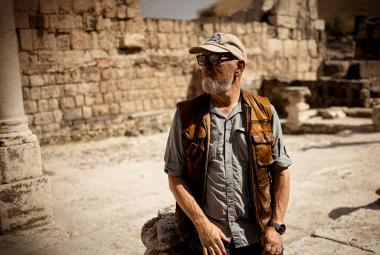
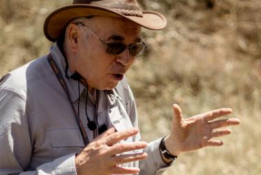
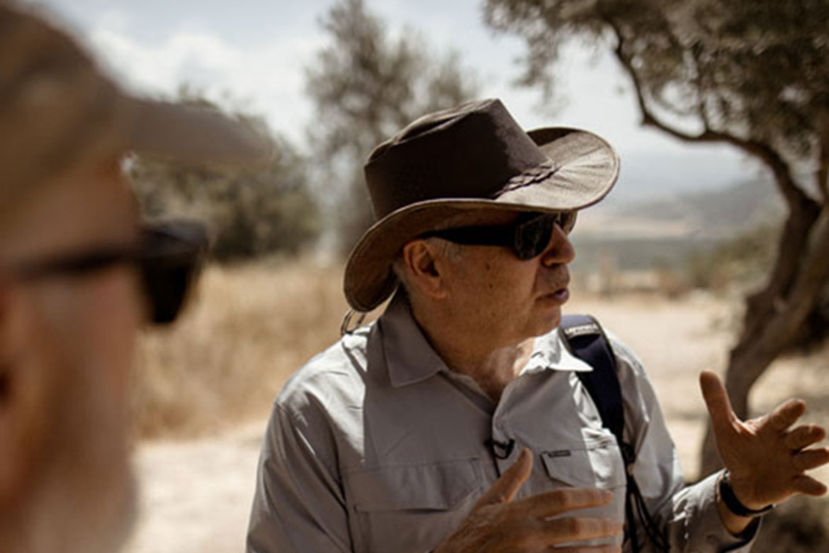
Into this intellectual minefield enters Professor Yosef Garfinkel. He studied at the Hebrew University, graduating with a Bachelor of Arts (BA) in geography and archaeology in 1981, a Master of Arts (MA) in prehistory and biblical archaeology in 1987, and a Doctor of Philosophy (PhD) in 1991. Garfinkel spent a Post-Doc year in 1992 at the Department of Anthropology and the Semitic Museum of Harvard University. Garfinkel is the Yigael Yadin1 Departmental Chair in Archaeology of Eretz Yisrael and Professor of Archaeology at the Hebrew University of Jerusalem. He began teaching in 1993 at the Department of Biblical Archaeology, Institute of Archaeology, The Hebrew University of Jerusalem. During his years at the Institute of Archaeology and until 2026, he guided 21 M.A thesis and 17 PhD dissertations. He has authored 35 books and over 200 articles on ancient architecture, farming, water sources, pottery, art, religion, and dance.
The Philistines
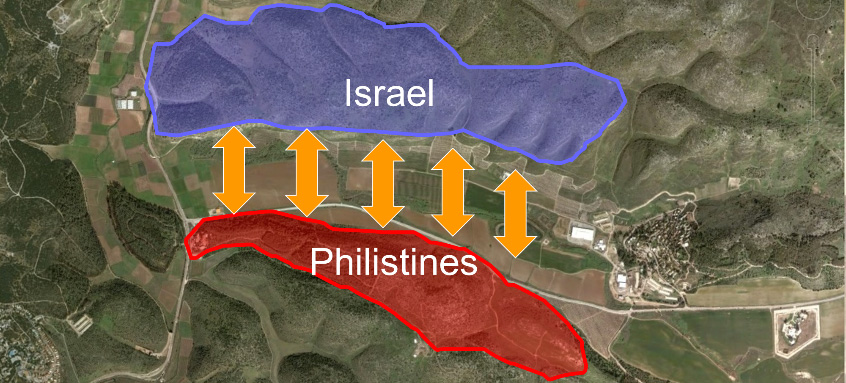
In 2007, Garfinkel began conducting excavations at Khirbet Qeiyafa. This previously unexplored site sits on the ridge north of the Valley of Elah. The Valley of Elah is an open field that lies between the inheritance of Judah and the land of the Philistines. Most are familiar with the famous battle that took place here between young David and Goliath, the Philistine champion from Gath.2 When you visit the Valley of Elah, you easily see the two ridge mountains on either side of this narrow valley. King Saul with the army of Israel would have stood on the northern ridge, and the Philistines would have stood on the southern ridge.3
After the Philistines’ defeat, this area became a military buffer zone between Israel and the Philistines. Israel’s fortified cities along this southern perimeter would serve as military outposts in the event of any hostile movements coming from the Philistines.
The Process
The archaeologist incorporates three parameters to thoroughly investigate a site.
- The WHAT: This is the FINDING that will be used to establish the significance of a site.
- The WHERE: This is the LOCATION that is used to validate the authenticity of the findings.
- The WHEN: This is the TIMING. For the archaeologist, this is referred to as stratigraphy, or excavated levels. For example, Tel Megiddo has 26 distinct “layers” that conceal 26 levels of previous civilizations.
Therefore, one of the principal tasks for an archaeologist is to determine the timing of the different destruction layers at the site under investigation.
Unlike most other ancient Israel cities that have been excavated, this fortress site is relatively simple. Garfinkel discovered that this site functioned only briefly as a city, with only one principal layer of settlement. Given its location and construction, it is clear that it was a military outpost that existed for a short time. Maybe for no more than 100 to 200 years. And then it was evacuated, or they left it uninhabited. Everything on this site is essentially from the same time frame, making it an archaeologist’s dream.
The What
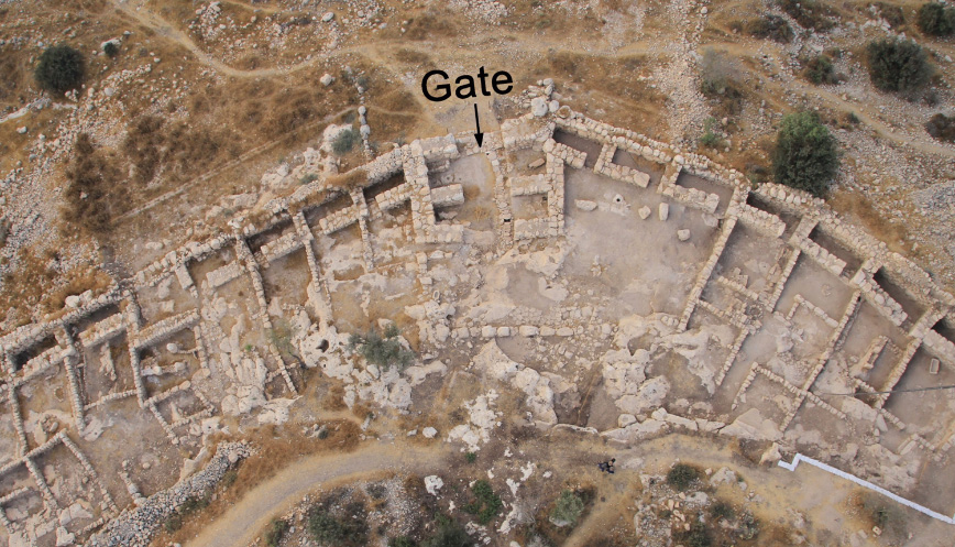
This fortified city sits on 2.3 hectares, 5.7 acres. It has two gates, two piazzas (public squares or marketplaces), and a belt of houses and public buildings. At this point, one might say, “What’s unique about that?” Straight away, the fact that it had gates made this special. If this were just a village that housed farmers, gates would be very expensive to make, to maintain, and to defend. So, normally, you wouldn’t have gates in a remote farming village. A closer inspection of these gates reveals their specific construction as associated with a military site. For the main gate,, you will notice an outward threshold, meaning the doors open out and are therefore harder to breach from the outside. Inside the gate, you find two other inner chambers on either side of the entrance road. Those provide for the successive barricades that would be erected to defend the city. Inside each of those side areas would be soldiers ready for crossfire. The style of this gate comes from the era of David and Solomon. When we take people to Tel Megiddo during our tours of Israel, we will show them the defensive side chambers, positioned just inside the main gate. There, they have six chambers, not four. The gate structures are all reliably dated to the time of Solomon.
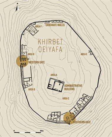 Next, this city has massive casement city walls. Rather than make one very thick wall, they would make walls that have hollow cavities in them. We do that with a concrete block wall today. This fortification technique dates back to Joshua’s conquest of the Promised Land. When Joshua sent spies into the city of Jericho, they found shelter with Rahab, who lived in one of these casement chambers
along the outer wall.4
At this point, it is important to note that this was not a military installation meant to withstand a long siege, but rather a watchtower with an outlook that could send a quick detachment of troops to gather reinforcements.
The Where
The Biblical narrative establishes the location.
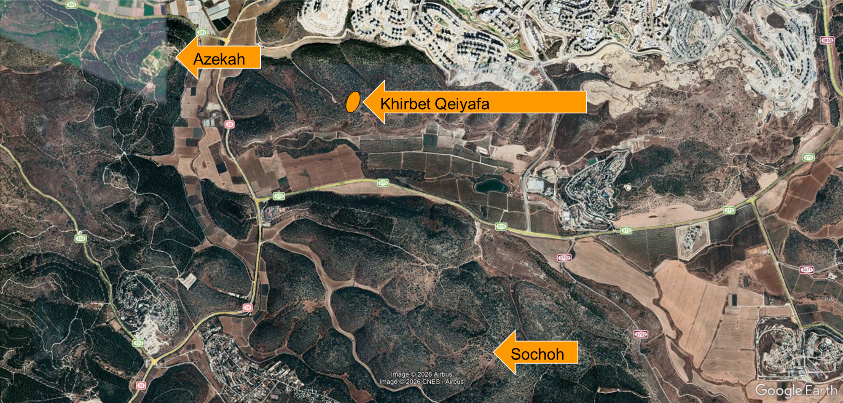
“Now the Philistines gathered their armies together to battle, and were gathered at Sochoh, which [belongs] to Judah; they encamped between Sochoh and Azekah, in Ephes Dammim. And Saul and the men of Israel were gathered together, and they encamped in the Valley of Elah, and drew up in battle array against the Philistines. The Philistines stood on a mountain on one side, and Israel stood on a mountain on the other side, with a valley between them.”
1 Samuel 17:1-3
The Valley of Elah is a long, shallow valley in the Shephelah region of Israel, it is southwest of Jerusalem and situated about 15 miles west of Bethlehem and 20 miles east of the Mediterranean Sea. It is about a day’s walk from Jerusalem. Sochoh was surveyed by Garfinkel in 2010 on behalf of the Hebrew University’s Institute of Archaeology. Rehoboam fortified the Sochoh (2 Chronicles 11:7). Azekah was fortified by Rehoboam during his reign, along with Lachish and other strategic sites (2 Chronicles 11:5–10). Therefore, the reference to the Valley of Elah and these two ancient, fortified cities enables us to focus on the correct location of this famous battlefield.
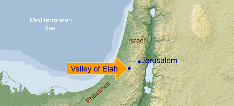
At the time of David, this area served as a buffer zone between Judah and the Philistines. Goliath was from Gath, which is about 12 miles southeast of the Valley of Elah. Geopolitically, this is the right place for David to establish a military outpost and place it under central administration.
The When
As the excavation of the site began, they found a very rich destruction layer dating to the 10th century BCE. Now, at this point, you’re most likely thinking, “How did they know that? It’s not like there is a date stamped on a piece of pottery or an old brass plaque with the founding date embossed on it. No, the primary way sites are dated today is with very accurate carbon dating.
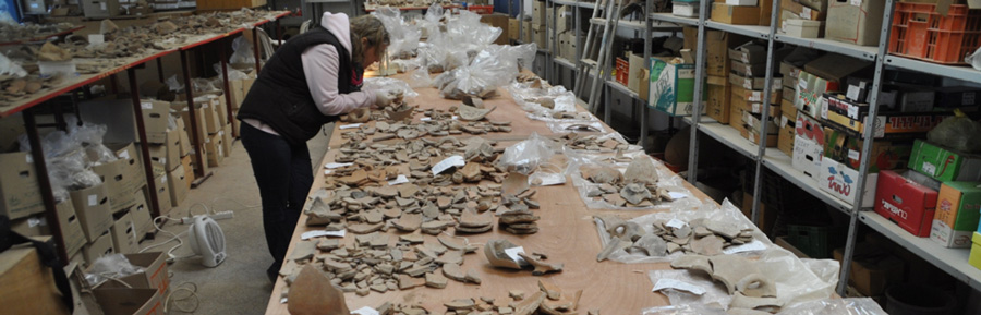
As they uncovered the site, they found many artifacts. They found lots of pottery, lots of instruments, and even writing. But they rejoiced most when they found four olive pits, something organic. Garfinkel’s team sent this important find to a lab that specializes in microarchaeology. Microarchaeology is a specialized branch of archaeology that focuses on analyzing the microscopic components of archaeological sites, which are often invisible to the naked eye. This includes micro-artifacts, micro-fossils, organic matter, and minerals embedded in sediments, soils, and artifacts, providing detailed insights into past human activities and environmental conditions.5 Unlike traditional archaeology, which emphasizes visible structures and artifacts, Microarchaeology extracts information from the microscopic record, offering a high-resolution perspective on the past.
There are five labs worldwide that conduct this type of analysis. One of them is in Jerusalem, called the Weizmann Institute. There’s also Oxford University in the UK. They are all vetted by the same central authorizing agency. Garfinkel sent off olive pits to the lab at Oxford University, and lo and behold, they dated to the first century BC using radiocarbon (C-14) measurements.
Therefore, if you find something that’s buried at that same level, it’s from that same era. Based on this scientific analysis, Garfinkel was confident that everything at this level is from the first century BC. No one will argue that they’re being fair in using our archaeological terms.
 The Proof
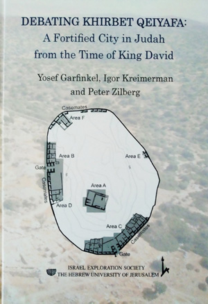
Professor Garfinkel collected and analyzed the findings from the Khirbet Qeiyafa site and documented his observations in a book, “Debating Khirbet Qeiyafa.”
Rather than simply making a blanket declaration, he used comparative analysis, which allows for independent comment and debate. Garfinkel identified six key areas he explored to establish the validity of his final conclusions.
Urban planning: The layout of this site is very similar to that of other Judean cities of the period. The casemates are oriented away from the gates, which is typical for the proposed time and place. There is a peripheral belt of buildings that abuts the city wall and incorporates the casemates as rear rooms. In modern terms, we would identify this as a master-planned community.
- Cooking habits: It has been said that archeology is the study of durable garbage. Not only were many pots, pans, and utensils found, but the durable remains of their eating habits give us a few clear clues as to who resided on this site. At first, the critics confidently claimed that Khirbet Qeiyafa was a Philistine site. Garfinkel’s team recovered over one hundred thousand bones. From these bones, they could determine the ethnic identity of the inhabitants. Bones are incredibly resilient when buried. What did they find? They found no pig bones or anything non-kosher. And yet the cities across the valley, which are Philistine, are full of residue of non-kosher foods.
At Canaanite sites, 4 to 5 percent of the animal bones are from pigs. At Philistine sites, up to 20 percent of the animal bones are pigs. What does that say about this city? This was not a Canaanite city; this was not a Philistine city. The inhabitants are clearly following the Levitical laws concerning food, which means they are of the Hebrew.
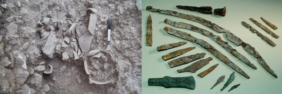
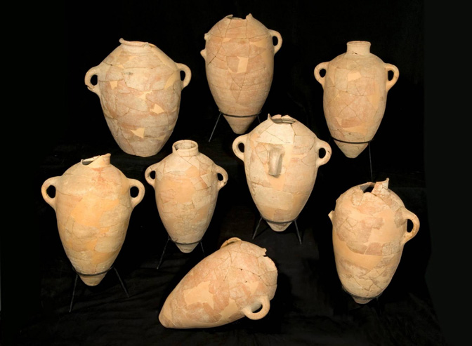 Central Administration: How do you prove that? In every government-controlled municipality, you will find the tax collector. How did they pay taxes in the ancient Middle East? You paid it by weight and measure. So, if you were taxed an Omer of wheat, you have to have a vessel that measures an Omer. Clay pots of a prescribed size and shape are used for collecting taxes. The existence of these precise containers, all in one place, is strong evidence of central administration.
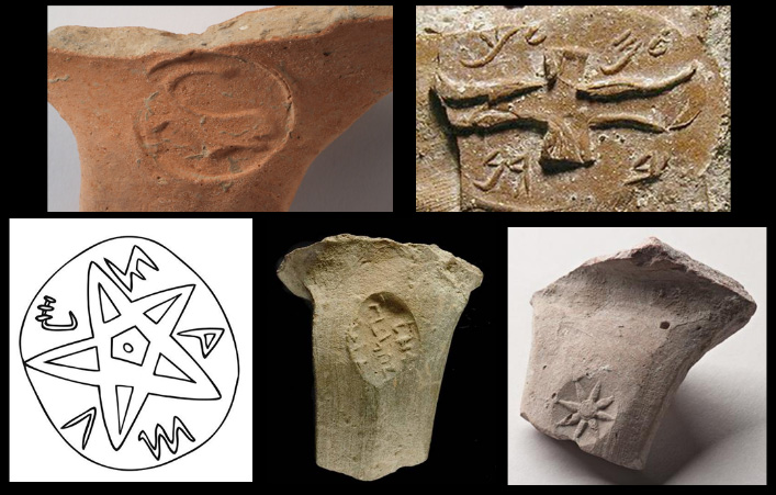
The excavation also uncovered pot handles with a long tradition of stamped jar handles (only found in Judah).
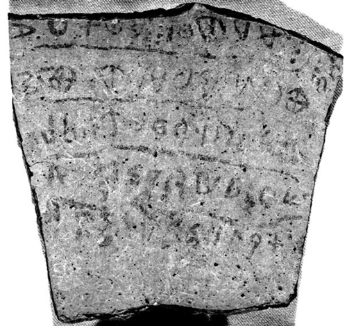 Writing: One discovery in particular, a pottery shard measuring about 15×16.5cm (5.9 in × 6.5 in) ostracon (a trapezoid-shaped potsherd) with five lines of text, discovered in Building II, Room B, in Area B of the excavations at Khirbet Qeiyafa. Hebrew University archaeologist Amihai Mazar said the inscription was the longest known Proto-Canaanite text.
In a lengthy 2009 article, Gershon Galil of Haifa University6 proposed an expansive reading of the ostracon with translation of the five lines as follows:
you shall not do [it], but worship the [Lord].
Judge the sla[ve] and the wid[ow] / Judge the orph[an]
[and] the stranger. [Pl]ead for the infant / plead for the po[or and]
the widow. Rehabilitate [the poor] at the hands of the king.
Protect the po[or and] the slave / [supp]ort the stranger.
Galil claimed that the language of the inscription is Hebrew and that 8 out of 18 words written on the inscription are exclusively biblical.
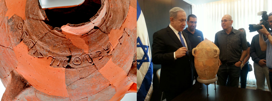
The team also found an incised jar with the inscription, “Isbaal son of Bedah.” The jar was fired around 1020–980 BC, placing it in the early Iron Age II period, overlapping with the biblical reign of King David. Who is the person being referenced on this jar? Isbaal (Esbaal) is often translated as Ishbosheth, the fourth son of King Saul.7 After Saul’s death, he will attempt to reign for two years.
Shortly after restoring the jar, Professor Garfinkel presented it to Israeli Prime Minister Benjamin Netanyahu.
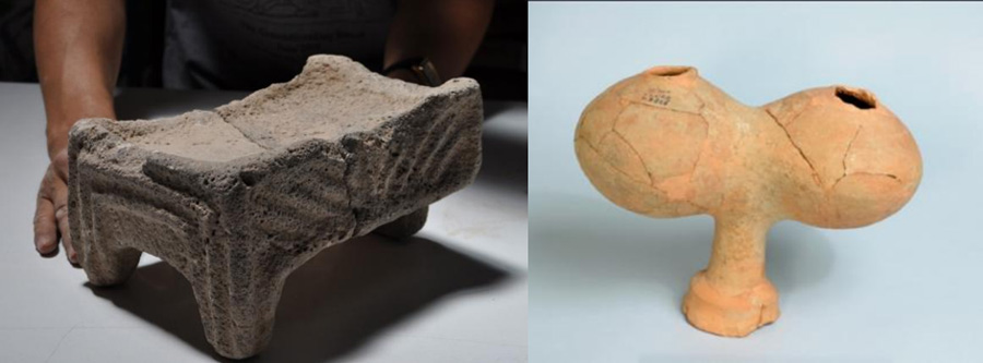
- Cult (Religious Items):
Don’t misunderstand the use of the term “cult object” when it comes to archaeology. It simply means an item that could be used in the practice of a religious expression. Garfinkel and his colleagues uncovered a rich assemblage of pottery, stone and metal tools, and many art and cult objects. These were found in three large rooms that served as cultic shrines, which in their architecture and finds correspond to the biblical description of a cult at the time of King David.
The cult objects include five standing stones (Massebot),8 two basalt altars, two pottery libation vessels and two portable shrines. No human or animal figurines were found, suggesting the people of Khirbet Qeiyafa observed the biblical ban on graven images.
One object that generated the greatest interest was a 35 cm-high stone shrine made of soft limestone and painted red. Its façade is decorated by two elements. The first are seven groups of roof-beams, each with three planks. The second decorative element is the recessed door. This type of door or window is known in the architecture of temples, palaces, and royal graves in the ancient Near East. This was a typical symbol of divinity and royalty at the time.
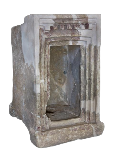 The stone model helps us understand obscure technical terms in the description of Solomon’s palace in 1 Kings 7:1-6. The text uses the term “Slaot,” which was mistakenly understood as pillars and can now be understood as a triglyph. Similar triglyphs and recessed doors can be found in the description of Solomon’s temple in 1 Kings 6, Verses 5, 31-33, and in the description of a temple by the prophet Ezekiel (41:6). These biblical texts are replete with obscure technical terms that have lost their original meaning over the millennia. Now, with the help of the stone model uncovered at Khirbet Qeiyafa, the biblical text is clarified. For the first time in history, we have actual objects from the time of David that can be linked to monuments described in the Bible.
- Geopolitical location:
From the vantage point of Khirbet Qeiyafa, you have a clear view of the Valley of Elah below. Gath, the home of Goliath, is to the southwest, as the rest of the Philistine nation stretches along the southern edge of the Mediterranean Sea. So again, geopolitically, this is the right place for David to establish a military outpost and place it under central administration. Now you can see what I am attempting to do with this 2-part series. We are providing credibility by adding corroborating evidence. We’re just not making a shouting into the dark here. We’re letting the case be presented piece by piece, line by line.
The Summary
We live in a world where proof seems to be established by how loud the voices are on social media. Rather than try to outshout the opposition, step back, stop yelling, and just turn the light on; darkness has to leave. That’s what Israel is doing today. They are letting the rocks cry out and shout the truth about ancient Israel.
Read Part 1 of The Evidence for Ancient Israel here.
You can watch the entire presentation by Ron Matsen on:
YouTube - https://www.youtube.com/watch?v=30qsoGA4kwA
K-House TV - https://www.khouse.tv/evidence
Notes:
1 https://jewishvirtuallibrary.org/yigael-yadin
2 1 Samuel 17
3 1 Samuel 17:3
4 Joshua 2
5 https://www.cambridge.org/core/books/microarchaeology/90A54AACBA0B4ADD7412F43EC91B91B9/listing
6 https://biblearchaeology.org/research-articles/ancient-hebrew-inscription-dated-to-time-of-david/
7 1 Chronicles 8:33
8 Massebot functioned as boundary markers and representations of divine presence, affirming territorial claims.